
Splash Island on the map, San Pedro, Philippines
Photo
Where is located Splash Island
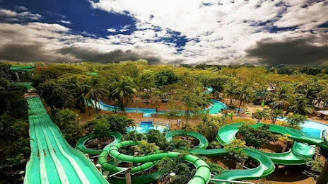
Splash Island — local attraction, which is located at Southwoods Ave, Biñan, 4024 Laguna, Philippines and belongs to the category — water park. Average visitor rating for this place — 4.0 (according to 1834 ratings, information from open sources and relevant for 2022).
Exact location — Splash Island, marked on the map with a red marker.
You can get directions to Splash Island on the map from your location.
What else is interesting in San Pedro? You can see all the sights if you go to the city page.
Coordinates
Splash Island, Philippines coordinates in decimal format: latitude — 14.348252047965989, longitude — 121.04011836140904. When converted to degrees, minutes, seconds Splash Island has the following coordinates: 14°20′53.71 north latitude and 121°2′24.43 east longitude.
Nearby cities
The largest cities that are located nearby:
- Bacoor — 10 km
- Dasmariñas — 10 km
- Las Piñas — 12 km
- Imus — 12 km
- Silang — 16 km
- Taguig — 19 km
- Calamba — 20 km
- Cavite City — 21 km
- Pasay — 21 km
- Tanza — 21 km
- Binangonan — 22 km
- Taytay — 25 km
- Pasig City — 27 km
- Cainta — 27 km
- Antipolo — 32 km
- Malabon — 36 km
- Quezon City — 36 km
- San Mateo — 39 km
- Meycauayan — 45 km
Distance to the capital
Distance to the capital (Manila) is about — 29 km.