 Puerto de la Duquesa
  La Serna de Iguña
  Pumalverde
  Puentenansa
  La Iglesia
  Casar de Periedo
  Fuengirola
  Renedo de Piélagos
  Villabanez
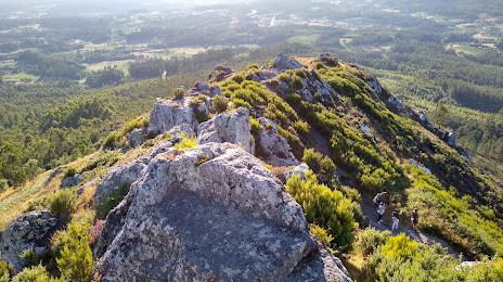
Pico Sacro on the map, A Estrada, Spain
Photo

Where is located Pico Sacro
Pico Sacro — local attraction, which is located at 490 m and belongs to the category — -. Average visitor rating for this place — 4.6 (according to 126 ratings, information from open sources and relevant for 2022).
Exact location — Pico Sacro, marked on the map with a red marker.
You can get directions to Pico Sacro on the map from your location.
What else is interesting in A Estrada? You can see all the sights if you go to the city page.
Coordinates
Pico Sacro, Spain coordinates in decimal format: latitude — 42.80682875369119, longitude — -8.447371110256736. When converted to degrees, minutes, seconds Pico Sacro has the following coordinates: 42°48′24.58 north latitude and -8°26′50.54 east longitude.
Nearby cities
The largest cities that are located nearby:
- Vigo — 53 km
- Ourense — 64 km
- A Coruña — 75 km
- Braga
(Portugal) — 127 km
- Porto
(Portugal) — 170 km
- Oviedo — 225 km
- León — 238 km
- Gijón — 245 km
- Coimbra
(Portugal) — 275 km
- Salamanca — 303 km
- Valladolid — 332 km
- Santander — 385 km
- Burgos — 394 km
- Amadora
(Portugal) — 439 km
- Queluz
(Portugal) — 440 km
- Badajoz — 441 km
- Lisbon
(Portugal) — 442 km
- Bilbao — 452 km
- Móstoles — 469 km
Distance to the capital
Distance to the capital (Madrid) is about — 476 km.
